We're pleased to share GIS posters here. We've grouped them by topic
and include date and time when poster designers will present in Zoom
about their work.
Policy Posters
Using GIS to Understand Regional Traffic
PatternsSpeaker: Bingyu Zhao, UC Berkeley
In the field of large-scale traffic modeling, GIS becomes an
indispensable tool in all stages of model development. However,
many
traffic engineers are not trained to be GIS specialists and GIS
visualization frequently becomes the bottleneck in our research.
In this poster, I
will present some of our recent case studies that uses GIS tools
(both conventional and new, browser-based) to visualize a variety
of traffic
phenomena and welcome advice in incorporating the most
cutting-edge developments.
YES IN MY BACKYARD: A Spatial Analysis of
ADU Interest in the City of San Diego Speaker: Elizabeth Owen,
UC Los Angeles
The purpose of this research project is to visualize interest in
accessory dwelling units within the City of San Diego’s
neighborhoods. ADUs offer an incremental and scaled solution for
increasing density in existing single-family neighborhoods that
are in need of increased housing opportunities. The outcome of
this research is a spatial analysis of ADU permit applications
that can contribute to our understanding of the factors that make
ADU development a viable affordable housing solution
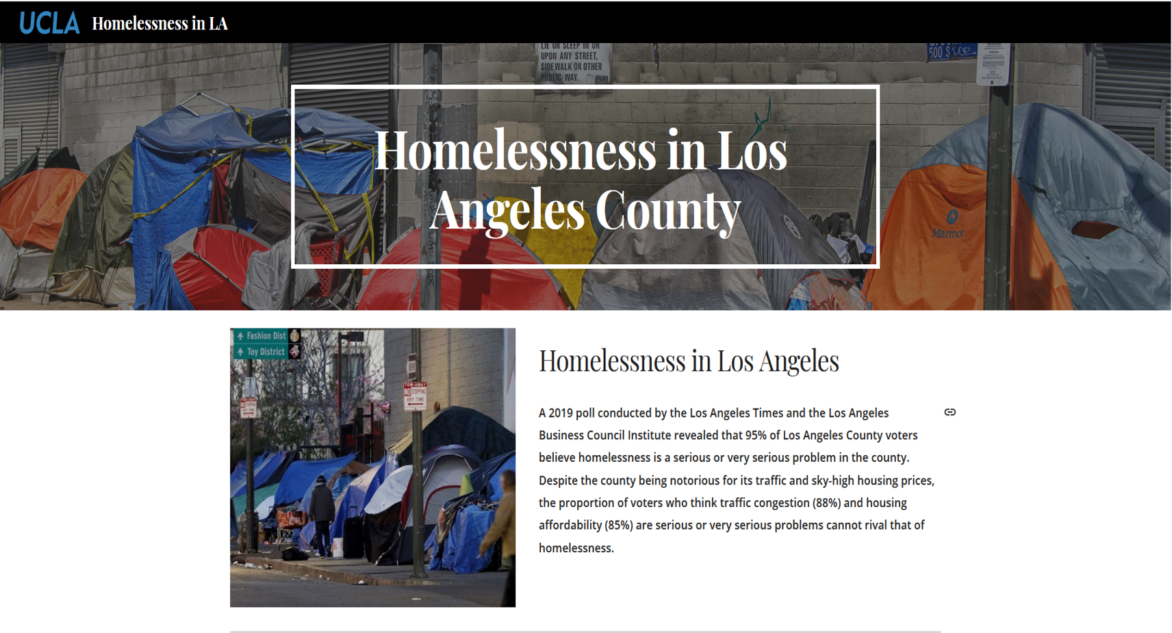
Visualizing Homelessness in Los Angeles
Speaker: Claire Chua, UC Los Angeles
Being the “different” one as a Geography major and GIS minor
among my “pre-med” and life science peers has not been easy. But
the rocky start opened me up to a new path of career and skill
interests that combines the best of both GIS and Public Health.
Join me in this live discussion about how I am beginning my
undergraduate journey in GIS and how I plan to inspire others with
my burning curiosity and passion for this versatile and promising
discipline.
Environmental Science and
Public Health Posters
Spatial Equity Mapping: Patterns and Distributions of Neighborhood Risk Speaker: Nicole
Pereira, UC Los Angeles and Jared Schor, UC Los Angeles
Using the Neighborhood Risk Index (NRI), an index comprised of 10
indicators or risk factors, we measure how prevalent social and
environmental risk factors are for children in a given city by
presenting one dimensional maps of neighborhood risk levels
classified by zero, low, medium, and high risk. We also display
spatial patterns for each risk factor within city boundaries.
These maps identify areas of opportunity in neighborhoods to
positively influence child development.
Spatial Disparities in the burden of COVID-19
by Social Determinants of Health Among Veterans in Veterans
Administration Speaker: Hoda S. Abdel Magid, Stanford
The purpose of this study is to examine spatial disparities in COVID-19
testing and test positivity among Veterans enrolled in Veterans Affairs
Healthcare (VA). We calculate and map age-adjusted and race-stratified
age-adjusted testing rates for each county in the contagious US separately
for White Veterans and Black Veterans after adjusting for community-level
social determinants of health. Rates were standardized to the nationwide
population of Veterans in active care at VA.
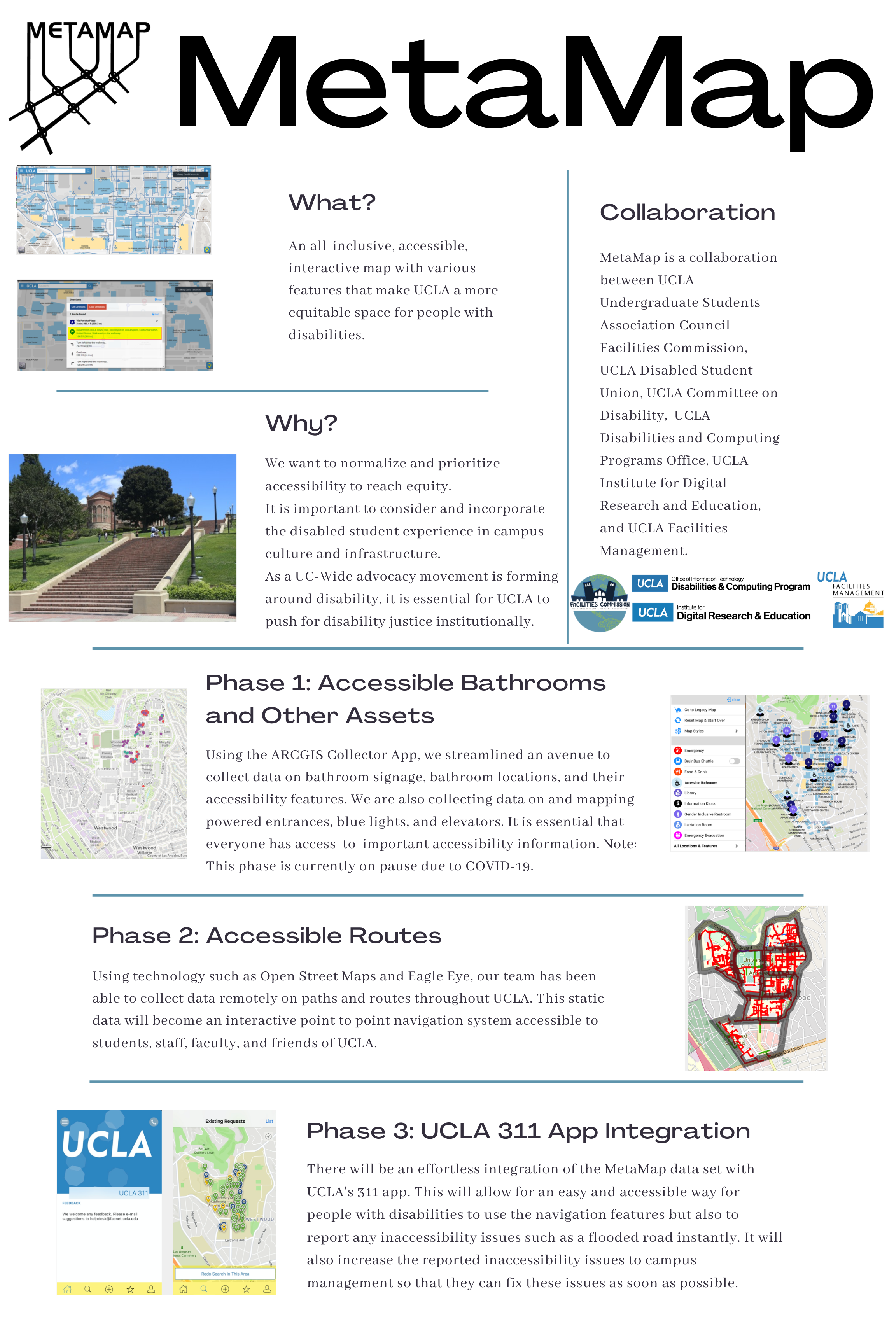
MetaMap Speaker: Alyssa Hemler, UC Los
Angeles
MetaMap is a collaboration between UCLA USAC Facilities
Commission, UCLA Committee on Disability, UCLA Disabilities and
Computing Programming Office, UCLA IDRE, and the UCLA Facilities
Maintenance Department. It will be an interactive map that can
guide people to accessible routes, bathrooms, elevators, power
entrances, and blue lights, which will be integrated with the UCLA
311 app. Reporting updates, problems, or obstructions to
accessibility will be easy to do via the UCLA 311 app.
GIS-Based Geologic Mapping and Analysis of
the Kaipo Mélange Speaker: Andre Mere, UC Riverside
I use a combination of 1m resolution LiDAR data, aerial
photography and in-person digital field mapping to generate a
new GIS-based large-scale geologic map of a fault-related
tectonic mélange exposed within the southernmost Kaipo Slip in
north Southland, New Zealand. Using new mapping and LiDAR data,
I construct a geologic cross-section and conduct topographic
analysis to investigate the relationship between tectonic
deformation of basement rocks and quaternary landscape response.